
SITE OF THE MONTH
Stainbrook Springs and Leavitt Conservation Properties
These two properties, located north of Caroline, Alberta, can easily be visited in one afternoon.
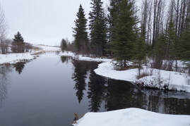
STAINBROOK SPRINGS: This 17-acre site is located north of Caroline (go north to on RR 61, then east at TWP Rd 373, then south on TWP road 55.) It is located on the east side of the road. The site is a fisheries enhancement area managed to protect important sport fish spawning and rearing habitat on the North Raven River (Stauffer Creek).
This location provides excellent bird and fish watching (for brown trout and brook trout during fall spawning season). The creek stays open all winter and exploring the area on foot or on snowshoes makes for a very pleasant hike.
For more information: https://www.albertadiscoverguide.com/site.cfm?grid=E3&number=58
LEAVITT: This 125-acre site is also north of Caroline. Go north on RR 61, then east on TWP Rd 373. It is on the north side of the road. This is a fisheries enhancement area protecting the head water springs of the North Raven River (Stauffer Creek). There are no defined trails, but there is a parking lot and the open habitat makes it easy to explore.
For more information: https://www.albertadiscoverguide.com/site.cfm?grid=E3&number=44LEAVITT
For more information: https://www.albertadiscoverguide.com/site.cfm?grid=E3&number=44LEAVITT